ORIENTATION AND NAVIGATION SYSTEMS


Wayfinding seems to be very high on the agenda of towns and cities so far this year and Streetwise has seen a brisk start to the year winning three new projects and holding discussions with a number of Local Authorities and Business Improvement Districts who are keen to improve wayfinding in their area.
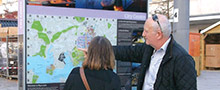
At the end of 2014 we completed a major project in Plymouth – one that involved 19 on-street monoliths containing both mapping and interpretive content plus a range of information provision at transport points and car parks.
We have made this project the focus of our second edition of Streetalk and we have highlighted some of our initiatives applied in Plymouth that we feel are relevant to many areas.
Feedback from both the Plymouth City Council and visitors alike has been very encouraging, and we are delighted to have been appointed by Sutton Harbour Holdings PLC to examine how we could develop a new system for what is Plymouth’s historic port, based on our work in Plymouth City Centre.

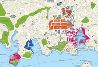
People try to assess distances and are often easily misled if maps do not deliver a realistic impression of how far a district or attraction is from where they are. In Plymouth we found the existing map acted counter to their objectives as it focused attention on the commercial district and its zoning and treatment of streets gave the impression that the coastline was further away and less accessible than the reality. So we set about re-centering the city. There is not space here to go into all that we considered but the two maps tell the story. The top map is the original. The two most important streets are the north – south running Armada Way, a tree lined boulevard and the east – west running Royal Parade. As you can see on the original map, the presentation of Armada Way left it obscured due to the tinting used to signify pedestrianised sections and it was cluttered with graphic elements to the extent that you could virtually not see that it was a continuous street leading from the rail station down to The Hoe, Plymouth’s amazing coast side park offering stunning views along the coastline. In addition to this the use of non connecting zones and their respective tinting led to the city’s shopping district in pink leaving visitors believing that the centre of this area was the heart of the city centre as opposed to the reality of it being the junction of Armada Way and Royal Parade.
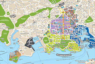
In the bottom map you can see the measures we put
in place. First of all we made it clear that Armada Way
and Royal Parade were the principal streets, this also
allowed the direct route towards the coastline to be
clear. We introduced further zone indicative tints to
connect the shopping district to The Hoe and avoid
what had looked like a set of ‘islands’ and a ‘no mans
land’ in terms of visitor interest. These changes were
immediately welcomed by all of the stakeholders in this
wayfinding project and these measures gave a much
stronger mapping foundation for us to develop the new
wayfinding system for the City. You will see that we also
introduced a circle on the map which showed that from
the new centre, almost all parts of the city’s places of
interest were within a 15 minute walking distance, a
fact tested by us and many others since!
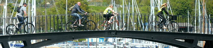
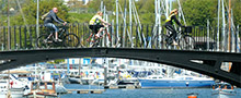
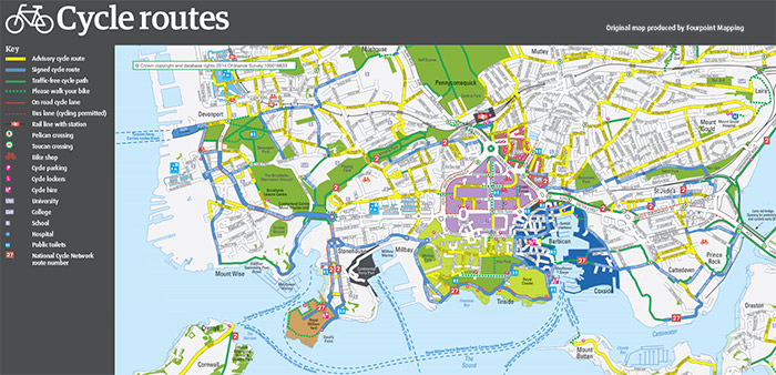
In Plymouth we were asked to review a series of fingerposts dedicated to the cyclist but also to consider how the new wayfinding system could be used to assist them as well as pedestrians. In looking closely at the different needs of both pedestrians and cyclists we recommended that the new monoliths for the city centre should carry a specific map for cyclists. Why a separate map? A number of reasons led us to this.
The first was that in trying to cater for all requirements on one map, the number of symbols and markings cluttered a single map making it harder to use for all and led to an even longer map key.
Another aspect was that the cyclist, due to the potentially greater distances they would travel compared to the same time on foot, would benefit from a map covering a greater area of the city.
The third reason is that Plymouth City Council already published a cycle route map and we felt that the onstreet map should be consistent with this. Lastly we also felt that the provision of this map reflected the City’s policy of encouraging cycling in and around the city centre.
When developing a wayfinding system it is necessary
to consider the variety of users and to look at how
a new system can cater for differing needs without
compromising its usability for all.
 Click to enlarge
The key to this is to tap into two things, the natural curiosity of people and their desire not to miss out on something. How can this be done?
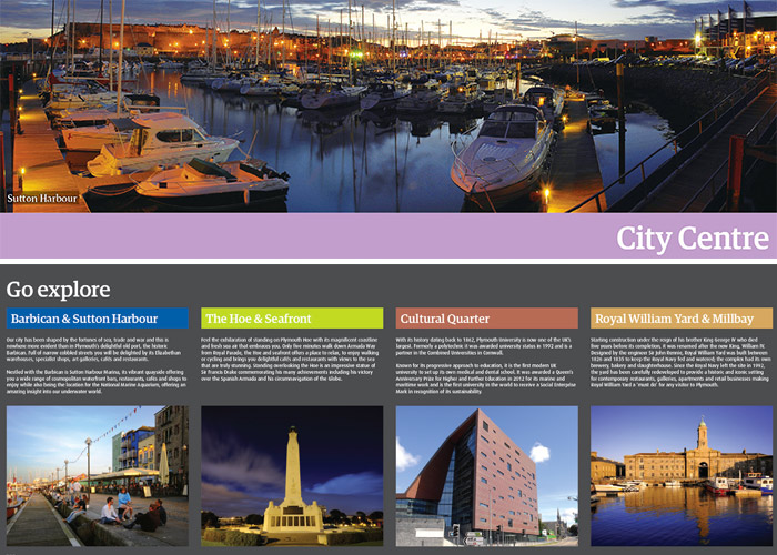
In Plymouth as elsewhere we have looked to ensure
we consistently promote other districts, particularly
those adjoining where the visitor is standing, making
it an easier reach in terms of distance. In Plymouth there are five key areas and on each monolith under
the title Go Explore we presented a short synopsis
of these other areas as well as an interesting image.
The use of zones and the tinting of them on the map
also helps with this as visitors can be shown that
there are different districts and this encourages the
feeling that their visit should include the exploration
of them.
 Go to Top
Efficient routing of visitors around a town or city is in everyone’s interests and ensures the best possible enhancement of the local economy. Many projects include a high degree of interpretive information to give visitors and local residents a full appreciation of the attractions and points of interest within an area.
Our scoping report is undertaken on a no obligation basis and sees us visit a town or city and conduct an in-depth survey of current wayfinding provision followed by a comprehensive report of recommendations, together with budgets – the cost of this report is not prohibitive and a quote can easily be provided.
For an informal discussion, please contact; Graham Macready, on 0131 229 5441 or email him at g.macready@streetwisesystems.com